Willadingen
| Willadingen | ||
|---|---|---|

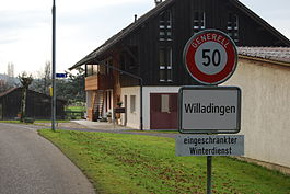
The entrance to Willadingen village
|
||
|
||
| Coordinates: 47°9′N 7°37′E / 47.150°N 7.617°ECoordinates: 47°9′N 7°37′E / 47.150°N 7.617°E | ||
| Country | Switzerland | |
| Canton | Bern | |
| District | Emmental | |
| Area | ||
| • Total | 2.16 km2 (0.83 sq mi) | |
| Elevation | 465 m (1,526 ft) | |
| Population (Dec 2015) | ||
| • Total | 203 | |
| • Density | 94/km2 (240/sq mi) | |
| Postal code | 3425 | |
| SFOS number | 0423 | |
| Surrounded by | Heinrichswil-Winistorf (SO), Höchstetten, Koppigen, Recherswil (SO) | |
| Website |
http://www.willadingen.ch SFSO statistics |
|
Willadingen is a municipality in the administrative district of Emmental in the canton of Bern in Switzerland.
Willadingen is first mentioned in 1214 as Willedingen.
The oldest evidence of humans in the municipal area are some neolithic flints in the Neumatt area, followed by a grave or a graveyard in Wigglismoos. The small community has always been politically, economically and religiously dependent on Koppigen. Today it is part of the Koppigen school district and parish. The close connection to Koppigen probably came about under Peter of Thorberg who bought land in the village from Ulrich of Urtinen in 1374. After his death in 1397, the Thorberg Charterhouse, which he had helped found, inherited all of his land. After the city of Bern accepted the Protestant Reformation and secularized the Chapterhouse in 1528, Bern acquired the village. Under Bernese rule Willadingen became part of the district of Koppigen.
The rural village has remained mostly agricultural with very little industry. In 2000, almost three-quarters of the working population commuted to jobs in nearby cities.
Willadingen has an area of 2.16 km2 (0.83 sq mi). Of this area, 1.48 km2 (0.57 sq mi) or 68.5% is used for agricultural purposes, while 0.61 km2 (0.24 sq mi) or 28.2% is forested. Of the rest of the land, 0.1 km2 (25 acres) or 4.6% is settled (buildings or roads).
Of the built up area, housing and buildings made up 4.2% and transportation infrastructure made up 0.5%. Out of the forested land, all of the forested land area is covered with heavy forests. Of the agricultural land, 51.9% is used for growing crops and 16.7% is pastures.
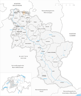
The municipality is located along the Ösch river, on the border with the Canton of Solothurn. It consists of the village of Willadingen, the hamlets of Mösli and Moosgasse and the new housing development of Lischmatt.
...
Wikipedia


