Willistown, Pennsylvania
| Willistown Township | ||
|---|---|---|
| Township | ||

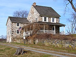
Okehocking Historic District
|
||
|
||
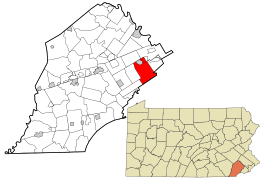
 Location in Chester County and the state of Pennsylvania. |
||
 Location of Pennsylvania in the United States |
||
| Coordinates: 39°59′00″N 75°28′59″W / 39.98333°N 75.48306°WCoordinates: 39°59′00″N 75°28′59″W / 39.98333°N 75.48306°W | ||
| Country | United States | |
| State | Pennsylvania | |
| County | Chester | |
| First Reference | 1681 | |
| Founded | 1704 | |
| Area | ||
| • Total | 18.27 sq mi (47.32 km2) | |
| • Land | 18.11 sq mi (46.90 km2) | |
| • Water | 0.16 sq mi (0.42 km2) | |
| Elevation | 351 ft (107 m) | |
| Population (2010) | ||
| • Total | 10,497 | |
| • Estimate (2016) | 10,898 | |
| • Density | 601.80/sq mi (232.36/km2) | |
| Time zone | EST (UTC-5) | |
| • Summer (DST) | EDT (UTC-4) | |
| Area code(s) | 610 and 484 | |
| FIPS code | 42-029-85352 | |
| Website | www |
|
Willistown Township is a township in Chester County, Pennsylvania, United States. The population was 10,497 at the 2010 census. At the 1860 census, the population of Willistown was 1,521, and in 1980 it was 8,269.
Originally settled by Lenni Lenape Native Americans, Willistown Township was part of the 50,000 acres (200 km2) Welsh Tract surveyed for William Penn in 1684. The Holmes Map of 1681 is the first reference to Willistown, calling it "Willeston". In 1704, Willistown was organized as a township.
A Native American reservation was located here and is memorialized by a monument.
The first roads in Willistown Township were Native American trails. In 1710, three cowpaths were established here: Goshen, Sugartown, and Boot. Those roads are still in existence, under the same names.
The West Chester Railroad, later to be a part of the Pennsylvania Railroad, had its eastern terminus at Malvern, in this township. The terminus was moved to Frazer in 1870.
Bartram's Covered Bridge, Garrett Farmstead, Okehocking Historic District, Sugartown Historic District, and White Horse Historic District are listed on the National Register of Historic Places.
According to the United States Census Bureau, the township has a total area of 18.2 square miles (47 km2), all of it land.
Willistown Township borders Easttown Township, Newtown Township, Edgmont Township, Westtown Township, East Goshen Township, East Whiteland Township, Tredyffrin Township, and the borough of Malvern. Most of Willistown Township's addresses are in ZIP codes 19355 and 19073, with small areas in ZIP codes 19382, 19380, 19301, and 19312.
...
Wikipedia

