Woody Point, Newfoundland and Labrador
| Woody Point | |
|---|---|
| Town | |

Woody Point from lookout
|
|
| Location of Woody Point in Newfoundland | |
| Coordinates: 49°30′N 57°56′W / 49.500°N 57.933°W | |
| Country |
|
| Province |
|
| Settled | 1849 |
| Incorporated | 1956 |
| Area | |
| • Total | 2.91 km2 (1.12 sq mi) |
| Elevation | 25 m (82 ft) |
| Population (2006) | |
| • Total | 355 |
| • Density | 121.8/km2 (315/sq mi) |
| Time zone | Newfoundland Time (UTC-3:30) |
| • Summer (DST) | Newfoundland Daylight (UTC-2:30) |
| Postal code span | A0K |
| Area code(s) | 709 |

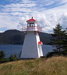
Woody Point Lighthouse in 2006
|
|
| Location | Woody Point Newfoundland Canada |
|---|---|
| Coordinates | 49°30′17.26″N 57°54′45.11″W / 49.5047944°N 57.9125306°W |
| Year first constructed | 1919 (first) 1952 (second) |
| Year first lit | 1959 (current) |
| Construction | wooden tower |
| Tower shape | square frustum tower with balcony and lantern |
| Markings / pattern | white tower, red lantern roof |
| Height | 6 metres (20 ft) |
| Focal height | 14 metres (46 ft) |
| Light source | solar power |
| Range | 4 nautical miles (7.4 km; 4.6 mi) |
| Characteristic | Fl R 4s. |
| Admiralty number | H0168 |
| CHS number | CCG 200 |
| NGA number | 2644 |
| ARLHS number | CAN-703 |
| Managing agent | Canadian Coast Guard |
Woody Point is a town located in the heart of Gros Morne National Park, on the western coast of Newfoundland. Situated on Bonne Bay, the Town of Woody Point encompasses three areas, Curzon Village, Woody Point and Winterhouse Brook. It has a total population of 281 residents. Woody Point is a Registered Heritage District and has a waterfront with many heritage buildings and four Registered Newfoundland and Labrador Heritage Structures. The community is served by Route 431.
Europeans were slow to settle the west coast of Newfoundland. The British were concentrated on the east coast, and the French were on the Grand Banks. The 1713 Treaty of Utrecht gave the French some area on the west coast which was extended in 1783 to the entire coast.
British settlement was spreading, as well. In 1800 the first British settlement in the Bonne Bay area occurred in Woody Point with the establishment of the firm of Joseph Bird from Sturminster Newton. He had an agent and premises to serve the British fishing interests which were principally migratory at this point. When fishermen began to stay during the winter rather than return to England, the pattern for permanent settlement was laid.
By 1904, the French had left the area to pursue fisheries farther up the coast. By this time, Woody Point was bustling. It was considered the capital of the area with banking and customs offices, merchants, and a harbour full of domestic and foreign vessels.
John Roberts and his wife, Emma, together with their four children are considered to be the first settlers of Woody Point. They came in 1849. By 1872, there were 129 families residing in the Bonne Bay area.
In 1873, the Bonne Bay Post Office was established in the home of J.R. Roberts, John Roberts' nephew. This house was one of the first built in the area and is still standing today. It is a blue clapboarded structure on the Shore Road left of the downtown. Plans are being made to restore this house.
Solomon Wilton was the second settler to Woody Point. It was Wilton who donated the land on which the present day Church of the Epiphany was built. A school and parsonage once stood on this sport. These early founding families are laid to rest in the Anglican cemetery on Shore Road.
In 1922, when Woody Point was experiencing the height of its population and commercial success, a devastating fire ripped through the downtown. The wind quickly carried the flames which shot all the way across the Bay to Norris Point. In all, 58 buildings were destroyed. The degree of commerce in the town never returned to the pre-fire level.
...
Wikipedia

