Yarmouth, Massachusetts
| Yarmouth, Massachusetts | ||
|---|---|---|
| Town | ||

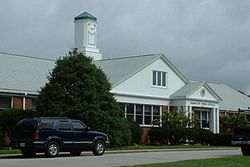
Yarmouth Town Offices
|
||
|
||
 Location in Barnstable County and the state of Massachusetts. |
||
| Coordinates: 41°42′N 70°14′W / 41.700°N 70.233°WCoordinates: 41°42′N 70°14′W / 41.700°N 70.233°W | ||
| Country | United States | |
| State | Massachusetts | |
| County | Barnstable | |
| Settled | 1639 | |
| Incorporated | January 7, 1639 | |
| Government | ||
| • Type | Open town meeting | |
| Area | ||
| • Total | 28.2 sq mi (73.1 km2) | |
| • Land | 24.1 sq mi (62.5 km2) | |
| • Water | 4.1 sq mi (10.5 km2) | |
| Elevation | 30 ft (9 m) | |
| Population (2010) | ||
| • Total | 23,793 | |
| • Density | 985/sq mi (380.4/km2) | |
| Time zone | Eastern (UTC-5) | |
| • Summer (DST) | Eastern (UTC-4) | |
| ZIP code | 02664 02673 02675 |
|
| Area code(s) | 508 / 774 | |
| FIPS code | 25-82525 | |
| GNIS feature ID | 0618262 | |
| Website | www |
|
Yarmouth (pronunciation: /ˈjɑːrmᵻθ/ YAR-mith) is a town in Barnstable County, Massachusetts, United States, Barnstable County being coextensive with Cape Cod. The population was 23,793 at the 2010 census.
The town is made up of three major villages: South Yarmouth, West Yarmouth, and Yarmouth Port.
Prior to European colonization, Yarmouth was inhabited by the Wampanoag, an Algonquian people. In the Wôpanâak language the area was called "Mattacheese". Wampanoag tribes living in Yarmouth at the time of European settlement included the Pawkunnawkuts on both sides of the lower Bass River, the Hokanums in what is now northeastern Yarmouth, and the Cummaquids in what is now western Yarmouth.
Yarmouth was organized and incorporated as part of the Plymouth Colony on September 3, 1639, following a settlement led by John Crowe (later Crowell), Thomas Howes and Anthony Thacher. Yarmouth originally included what is now the town of Dennis, which was incorporated as a separate community on June 19, 1793. Yarmouth is named after Great Yarmouth, a town in the county of Norfolk, on the east coast of England, which is itself at the mouth of the River Yare.
...
Wikipedia

