Zeila
|
Zeila Saylac زيلع |
|
|---|---|
| Town | |

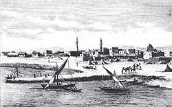
19th-century engraving of Zeila
|
|
| Location in Somaliland. | |
| Coordinates: 11°21′14″N 43°28′26″E / 11.35389°N 43.47389°ECoordinates: 11°21′14″N 43°28′26″E / 11.35389°N 43.47389°E | |
| Country |
|
| Region | Salal |
| Established | ca. 1st century CE |
| Time zone | EAT (UTC+3) |
| Climate | BWh |
Zeila (Somali: Saylac, Arabic: زيلع), also known as Zaila, is a port city in the northwestern Salal region of Somalia.
In antiquity, it was identified with the commercial port of Avalites described in the 1st century Greco-Roman travelogue the Periplus of the Erythraean Sea, an area that was situated in the historic northern Barbara region. The town evolved into an early Islamic center with the arrival of Muslims shortly after the hijra. By the 9th century, Zeila was the capital of the Ifat Sultanate, and a major port for its successor state the Adal Sultanate, it would attain its height of prosperity a few centuries later in the 16th century. The city subsequently came under British protection in the 18th century.
The city of Zeila is inhabited by the Gadabuursi a (clan)of the Somali people.The people in the region converted from Abyssinian/ Amhara to Somali after Imam Ahmad ibn Ibrahim al-Ghazi (Ahmad "Gurey" or "Gran") invaded the Abyssinian Empire.[19] This campaign is historically known as the Conquest of Abyssinia (Futuh al Habash).
Zeila is situated in the Awdal region in northwest Somalia. Located on the Gulf of Aden coast near the Djibouti border, the town sits on a sandy spit surrounded by the sea. It is known for its coral reef, mangroves and offshore islands, which include the Saad ad-Din archipelago named after the Somali Sultan Sa'ad ad-Din II of the Sultanate of Ifat. Landward, the terrain is unbroken desert for some fifty miles. Berbera lies 170 miles (270 km) southeast of Zeila, while the city of Harar in Ethiopia is 200 miles (320 km) to the west.
...
Wikipedia

