Zoar Valley
| Zoar Valley Multiple Use Area | |
|---|---|

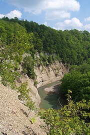
The Cattaraugus Creek's South Branch winding through a gorge within the Zoar Valley Multiple Use Area
|
|
|
Location of Zoar Valley within New York State
|
|
| Location | Cattaraugus and Erie counties, New York |
| Nearest city | Gowanda |
| Coordinates | 42°26′20″N 78°53′38″W / 42.439°N 78.894°WCoordinates: 42°26′20″N 78°53′38″W / 42.439°N 78.894°W |
| Area | 3,014 acres (12.20 km2) |
| Established | 1961 |
| Governing body | New York State Department of Environmental Conservation |
Zoar Valley is an area of deep gorges along the Main and South branches of Cattaraugus Creek in western New York, United States. The valley is located along the border of Erie County and Cattaraugus County, roughly between the villages of Gowanda to the west and Springville to the east.
The core area surrounding the confluence of the Cattaraugus Creek's Main and South branches is protected as the Zoar Valley Multiple Use Area, a conservation area located within the towns of Collins, Otto, and Persia. The protected area is managed by the New York State Department of Environmental Conservation, and is open to the public for fishing, hunting, hiking, white-water rafting, and wildlife and scenic viewing.
Canyon depths within the Zoar Valley Multiple Use Area are the greatest within the entire Cattaraugus Creek corridor, ranging up to 380 feet (120 m) along the South Branch and 480 feet (150 m) along the Main Branch. Several nearly vertical rock faces approach 400 feet (120 m) in height. The property also contains large stands of old-growth forest with trees of unusual size and height, which are further protected as part of the state-designated Zoar Valley Unique Area.
Zoar Valley is located along the border of Erie County and Cattaraugus County in New York, roughly between the villages of Gowanda to the west and Springville to the east.Cattaraugus Creek flows through the valley. An additional gorge formed by the Cattaraugus Creek's South Branch stretches south toward the village of Cattaraugus.
...
Wikipedia

