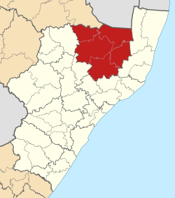
Zululand District Municipality
| Zululand | ||
|---|---|---|
| District municipality | ||
|
||
 Location in KwaZulu-Natal |
||
| Country | South Africa | |
| Province | KwaZulu-Natal | |
| Seat | Ulundi | |
| Local municipalities | ||
| Government | ||
| • Type | Municipal council | |
| • Mayor | Mpiyakhe Hlatshwayo | |
| Area | ||
| • Total | 14,799 km2 (5,714 sq mi) | |
| Population (2011) | ||
| • Total | 803,575 | |
| • Density | 54/km2 (140/sq mi) | |
| Racial makeup (2011) | ||
| • Black African | 98.0% | |
| • Coloured | 0.2% | |
| • Indian/Asian | 0.2% | |
| • White | 1.4% | |
| First languages (2011) | ||
| • Zulu | 94.3% | |
| • English | 1.5% | |
| • Afrikaans | 1.3% | |
| • Southern Ndebele | 1.1% | |
| • Other | 1.8% | |
| Time zone | SAST (UTC+2) | |
| Municipal code | DC26 | |
Zululand is one of the 11 district municipalities ("districts") of KwaZulu-Natal province. The seat of Zululand is Ulundi. The majority of its 804,456 people speak IsiZulu (2001 Census). The district code is DC26. It is part of a larger historical area also known as Zululand.
Zululand is surrounded by:
The district contains the following local municipalities:
The following statistics are from the 2001 census.
Election results for Zululand in the South African general election, 2004.
Coordinates: 28°19′S 31°25′E / 28.317°S 31.417°E
...
Wikipedia

