Ainderby
| Ainderby Steeple | |
|---|---|
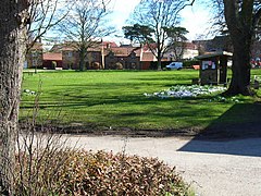
 Spring flowers on the village green, Ainderby Steeple |
|
| Ainderby Steeple shown within North Yorkshire | |
| Population | 298 (including North Otteringham and Warlaby. 2011) |
| OS grid reference | SE333921 |
| District | |
| Shire county | |
| Region | |
| Country | England |
| Sovereign state | United Kingdom |
| Post town | NORTHALLERTON |
| Postcode district | DL7 9 |
| Police | North Yorkshire |
| Fire | North Yorkshire |
| Ambulance | Yorkshire |
| EU Parliament | Yorkshire and the Humber |
| UK Parliament | |
Ainderby Steeple is a village and civil parish in the Hambleton district of North Yorkshire, England. Ainderby Steeple is situated on the A684 approximately 2.6 miles (4.2 km) south-west of the County Town of Northallerton, and to the immediate east of Morton-on-Swale.
The village is mentioned twice in the Domesday Book as Eindrebi. Some of the lands were part of the manor of Northallerton at the time of the Norman invasion which was held by Edwin, Earl of Mercia. After Edwin's rebellion of 1071, it became Crown property (indeed, the only Crown property in the entire Land of Count Alan). Most of the other land was in the manor of Ellerton-on-Swale with land held by Thorkil, Ulfkil before the Norman invasion and Ansketil of Forneaux afterwards. The Funeaux family are recorded as lords of the manor thereafter untiol the early 14th century, when Geoffrey le Scrope bought the lands. The manor continued to be owned by his descendants, albeit with a couple of incidents when the Crown took possession, until 1517 when the eleventh Lord Scrope had no male heir. The manor was divided among his children, and ended up in the possession of Robert Roos by way of the Strangeway family. By the nineteenth century claims to the manor had fallen into abeyance.
The topynomy of the village is derived from the Old Norse personal name of Eindrithi and the wordbi for farm with the addition of the Anglian word stēpel for steeple, giving Eindrithi's farm with a steeple.
The village lies within the Richmond UK Parliament constituency. It also lies within the Swale electoral division of North Yorkshire County Council and the Morton-on-Swale ward of Hambleton District Council.
The Parish boundary to the west of the village extends up to the outskirts of Morton-on-Swale and runs roughly north to south from a half mile north of the village to the south of Green Hills farm. The eastern boundary is formed by the River Wiske just one mile away and extends from just north of Barstow Hall farm to the outskirts of Warlaby. The northern boundary runs slightly north eastwards a half a mile from the A648. The neighbouring parishes consist of Yafforth, Romanby, Thrintoft, Morton-on-Swale and Warlaby.
...
Wikipedia

