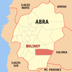
Boliney, Abra
| Boliney | ||
|---|---|---|
| Municipality | ||
|
||
 Map of Abra with Boliney highlighted |
||
| Location within the Philippines | ||
| Coordinates: 17°23′N 120°49′E / 17.38°N 120.82°ECoordinates: 17°23′N 120°49′E / 17.38°N 120.82°E | ||
| Country |
|
|
| Region | Cordillera Administrative Region (CAR) | |
| Province | Abra | |
| District | Lone District of Abra | |
| Barangays | 8 (see Barangays) | |
| Government | ||
| • Type | Sangguniang Bayan | |
| • Mayor | Benido L. Balao-as Sr. | |
| • Electorate | 2,790 voters (2016) | |
| Area | ||
| • Total | 216.92 km2 (83.75 sq mi) | |
| Population (2015 census) | ||
| • Total | 3,573 | |
| • Density | 16/km2 (43/sq mi) | |
| Time zone | PST (UTC+8) | |
| ZIP code | 2815 | |
| PSGC | 140102000 | |
| Area code(s) | +63 (0)74 | |
| Income class | 5th municipal income class | |
Boliney, officially the Municipality of Boliney (Ilocano: Ili ti Boliney, Filipino: Bayan ng Boliney), is a municipality in the province of Abra in the Cordillera Administrative Region (CAR) of the Philippines. The population was 3,573 at the 2015 census. In the 2016 electoral roll, it had 2,790 registered voters.
Boliney is bounded to the north by Sallapadan, Bucloc, and Daguioman, to the east by Tubo and the provinces of Kalinga and Mountain Province, and to the west by of Luba and Manabo.
Boliney is located at 17°23′N 120°49′E / 17.38°N 120.82°E.
According to the Philippine Statistics Authority, the municipality has a land area of 216.92 square kilometres (83.75 sq mi) constituting 5.21% of the 4,165.25-square-kilometre- (1,608.21 sq mi) total area of Abra.
...
Wikipedia


