Canton Viaduct
| Canton Viaduct | |
|---|---|

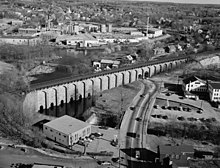
A west side view of the Canton Viaduct looking south with the former Paul Revere Copper Rolling Mill in the background, April 1977
|
|
| Coordinates | 42°09′32″N 71°09′14″W / 42.15889°N 71.15389°WCoordinates: 42°09′32″N 71°09′14″W / 42.15889°N 71.15389°W |
| Carries |
2 tracks (standard gauge) presently serving:
|
| Crosses |
|
| Locale | Canton, Massachusetts |
| Other name(s) |
|
| Maintained by | Amtrak (owned by the Massachusetts Bay Transportation Authority (MBTA) |
| Heritage status | |
| Characteristics | |
| Design | Blind arcade cavity wall |
| Material |
|
| Total length | 615' (built on a one degree ) |
| Width |
|
| Height |
Varies due to valley contour, built with a stepped foundation.
|
| Longest span | 2 at 28' (granite/concrete deck arches over the granite roadway portal) |
| No. of spans |
71 total:
|
| Piers in water | 7 (15 on land) |
| Load limit | Unknown, currently carries Amtrak's 100-ton Acela Express up to 125 MPH |
| Clearance above | Approximately 21' from top of rails to contact wires of the catenary system |
| Clearance below |
|
| History | |
| Designer | William Gibbs McNeill, Chief Engineer for the Boston & Providence Railroad (B&P) |
| Construction begin | April 20, 1834 |
| Opened | July 28, 1835 |
| Statistics | |
| Daily traffic |
|
|
Canton Viaduct
|
|
| Location | Neponset and Walpole Sts., Canton, Massachusetts |
| Built | 1834 |
| NRHP Reference # | 84002870 |
| Added to NRHP | September 20, 1984 |

Canton River Valley at the intersection of Neponset St. and Walpole St.
|
|
2 tracks (standard gauge) presently serving:
Varies due to valley contour, built with a stepped foundation.
71 total:
Canton Viaduct is a blind arcade cavity wall railroad viaduct built in 1834-35 in Canton, Massachusetts, for the Boston and Providence Railroad (B&P).
At its completion, it was the longest (615 feet) and tallest (70 feet) railroad viaduct in the world; today, it is the last surviving viaduct of its kind. It has been in continuous service for 181 years; it now carries high-speed passenger and freight rail service.
The Canton Viaduct's walls are similar to the ancient curtain wall of Rhodes (built about 400 BCE) with rusticated stone. It supports a train deck about 60 feet (18 m) above the Canton River, the east branch (tributary) of the Neponset River. The stream pool passes through six semi-circular portals in the viaduct, flowing to a waterfall about 50 feet downstream.
The viaduct was the final link built for the B&P's then 41-mile mainline between Boston, Massachusetts; and Providence, Rhode Island. Today, the viaduct serves Amtrak's Northeast Corridor, as well as Massachusetts Bay Transportation Authority (MBTA) Providence/Stoughton Line commuter trains. It sits 0.3 miles (0.5 km) south of Canton Junction, at milepost 213.74, reckoned from Pennsylvania Station in New York City, and at the MBTA's milepost 15.35, reckoned from South Station in Boston.
...
Wikipedia
