Cholesbury
| Cholesbury | |
|---|---|
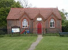
 Cholesbury Village Hall |
|
| Cholesbury shown within Buckinghamshire | |
| OS grid reference | SP930070 |
| • London | 28 mi (45 km) |
| Civil parish | |
| District | |
| Shire county | |
| Region | |
| Country | England |
| Sovereign state | United Kingdom |
| Post town | Tring |
| Postcode district | HP23 |
| Dialling code | 01494 |
| EU Parliament | South East England |
| UK Parliament | |
| Website | [1] |
Cholesbury (recorded as Chelwardisbyry in the 13th century) is a village in Buckinghamshire, England, on the border with Hertfordshire. It is situated in the Chiltern Hills, about 4 miles (6.4 km) east of Wendover, 5 mi (8.0 km) north of Chesham and 5 mi (8.0 km) from Berkhamsted.
Cholesbury is one of four villages comprising Cholesbury-cum-St Leonards (where the 2011 Census population was included), a civil parish within Chiltern District. Braziers End is a hamlet which has always been closely associated with Cholesbury.
It is a rural community and most local people rely for employment on neighbouring towns, the proximity of London and the availability of broadband technology.
At 178 acres (0.72 km2), Cholesbury is one of the smallest villages in the county and is located within Chiltern downland landscape on the upland plateau and close to the chalk escarpment which overlooks the Aylesbury Vale. At its highest point the village is some 650 feet (200 m) above sea level.
The geology of the area has dictated the land use. The soil comprises gravely clay, intermixed with flints, small pebbles and öolite over a chalk formation. Several examples of puddingstones a characteristic form of this aggregate have been found locally. There are no streams in the area due to the porous chalk sub soil. In places the occurrence of clay close to the surface accounts for several natural ponds fed by springs. Until connection with mains water in the mid-20th century, the scarcity of water had necessitated the sinking of deep wells and capture of rainwater.
In contrast to nearby areas of the Chilterns more land is given over to open space, namely agricultural, both arable and pasture; paddocks; heathland and most significantly the Common on either side of which the majority of houses are arranged. Mature woodland is a feature, including a stand of beech trees which mark out the circumference of the hillfort. Some beech plantation remains formerly associated with the chair-making industry in High Wycombe. Both chalk and a small amount of clay have been extracted over the years. The latter as a raw material for pottery and more recently brick-making. Meanwhile, in more recent times flint was dug out for road making. Both activities have left their mark in the form of small mounds and shallow depressions.
...
Wikipedia

