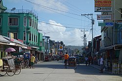
Guiuan, Eastern Samar
| Guiuan | |
|---|---|
| Municipality | |

Guiuan's Lugay Street in 2016
|
|
 Map of Eastern Samar with Guiuan highlighted |
|
| Location within the Philippines | |
| Coordinates: 11°02′N 125°44′E / 11.03°N 125.73°ECoordinates: 11°02′N 125°44′E / 11.03°N 125.73°E | |
| Country | Philippines |
| Region | Eastern Visayas (Region VIII) |
| Province | Eastern Samar |
| Congr. district | Lone district of E. Samar |
| Barangays | 60 |
| Government | |
| • Mayor | Cristopher Sheen P. Gonzales |
| Area | |
| • Total | 175.49 km2 (67.76 sq mi) |
| Population (2015 census) | |
| • Total | 52,991 |
| • Density | 300/km2 (780/sq mi) |
| Time zone | PST (UTC+8) |
| ZIP code | 6809 |
| Dialing code | +63 (0)55 |
| Website | guiuan-esamar |
Guiuan (IPA: ['gi.wan]) is a first-class municipality in the province of Eastern Samar, Philippines. As of the 2015 census, it had a population of 52,991 people.
Guiuan played a significant part in Philippine history. In the 16th century, when Ferdinand Magellan discovered the Philippines, it is believed that he first landed on the island of Homonhon. It is probably because of this that the majority of the population of the town are Catholics. The town's church, the Church of the Immaculate Conception, is one of the oldest in the country.
During the Second World War, Guiuan served as one of the Alliance's bases. Now all that is left of the American occupation are concrete slabs which once served as the foundations of a vast supply depot, and an air strip, which now serves as the town's own airport.
As well as a rich historical background, Guiuan has many scenic spots. Being a coastal town on the Pacific side, the town has many white-sand beaches that are suitable for swimming and surfing.
The municipality of Guiuan is located at the southernmost tip of Samar Island. It is bounded on the north by the municipality of Mercedes, on the east by the Pacific Ocean, on the south by the Surigao Strait, and on the west by the Leyte Gulf.
Clustered around the municipality are numerous islands and islets such as Manicani, Calicoan, Sulangan, Candulo, Homonhon, Suluan and Tubabao. They are protected as part of the marine reserve known as the Guiuan Protected Landscape and Seascape.
...
Wikipedia

