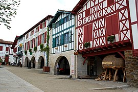
La Bastide-Clairence
| La Bastide-Clairence | ||
|---|---|---|
| Commune | ||

The Town Hall Square
|
||
|
||
| Coordinates: 43°25′42″N 1°15′19″W / 43.4284°N 1.2552°WCoordinates: 43°25′42″N 1°15′19″W / 43.4284°N 1.2552°W | ||
| Country | France | |
| Region | Nouvelle-Aquitaine | |
| Department | Pyrénées-Atlantiques | |
| Arrondissement | Bayonne | |
| Canton | Pays de Bidache, Amikuze et Ostibarre | |
| Intercommunality | CA Pays Basque | |
| Government | ||
| • Mayor (2001–2008) | Léopold Darritchon | |
| Area1 | 23 km2 (9 sq mi) | |
| Population (2010)2 | 997 | |
| • Density | 43/km2 (110/sq mi) | |
| Time zone | CET (UTC+1) | |
| • Summer (DST) | CEST (UTC+2) | |
| INSEE/Postal code | 64289 /64240 | |
| Elevation | 7–192 m (23–630 ft) (avg. 28 m or 92 ft) |
|
|
1 French Land Register data, which excludes lakes, ponds, glaciers > 1 km² (0.386 sq mi or 247 acres) and river estuaries. 2Population without double counting: residents of multiple communes (e.g., students and military personnel) only counted once. |
||
1 French Land Register data, which excludes lakes, ponds, glaciers > 1 km² (0.386 sq mi or 247 acres) and river estuaries.
La Bastide-Clairence (Basque: Bastida Arberoa) is a commune in the Pyrénées-Atlantiques department in the Nouvelle-Aquitaine region of south-western France.
The inhabitants of the commune are known as Bastidots or Bastidotes.
The village is a member of the Les Plus Beaux Villages de France ("The most beautiful villages of France") association.
La Bastide-Clairence is located in the former province of Lower Navarre some 20 km east by south-east of Bayonne and 5 km north-east of Hasparren. Access to the commune is by the D10 road which branches from the D936 north of the commune and comes south to the village continuing south to join the D251 just west of Ayherre. Part of the D510 forms the western border of the commune as it goes south to join the D10 near Hasparren. The D123 goes east from the village through the length of the commune to Amorots-Succos to the south-east. The D610 connects the D510 to the D10 in the commune. The commune is mostly farmland interspersed with forest.
La Joyeuse stream flows from the south through the village and continues north to become the Aran which joins the Adour at Urt. The Arbéroue stream flows from the south-east northwards through the eastern part of the commune to join the Lihoury north-east of the commune.
The commune name in Basque is Bastida or Bastida Arberoa and in Gascon Occitan is La Bastida Clarença.
...
Wikipedia


