Lesser Poland Voivodeship
|
Lesser Poland Voivodeship Województwo małopolskie |
|||
|---|---|---|---|
| Voivodeship | |||
|
|||
 Location within Poland |
|||
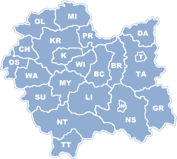
 Division into counties |
|||
| Coordinates (Kraków): 50°3′41″N 19°56′18″E / 50.06139°N 19.93833°E | |||
| Country |
|
||
| Capital | Kraków | ||
| Counties |
3 cities, 19 land counties *
|
||
| Area | |||
| • Total | 15,108 km2 (5,833 sq mi) | ||
| Population (31-03-2014) | |||
| • Total | 3,406,000 | ||
| • Density | 230/km2 (580/sq mi) | ||
| • Urban | 1,619,235 | ||
| • Rural | 1,648,496 | ||
| Car plates | K | ||
| Website | http://www.malopolskie.pl/ | ||
|
|||
Lesser Poland Voivodeship (in Polish, województwo małopolskie [vɔjɛˈvut͡stfɔ mawɔˈpɔlskʲɛ]), also known as Małopolska Voivodeship or Małopolska Province, is a voivodeship (province), in southern Poland. It has an area of 15,108 square kilometres (5,833 sq mi), and a population of 3,267,731 (2006).
It was created on 1 January 1999 out of the former Kraków, Tarnów, Nowy Sącz and parts of Bielsko-Biała, Katowice, Kielce and Krosno Voivodeships, pursuant to the Polish local government reforms adopted in 1998. The province's name recalls the traditional name of a historic Polish region, Lesser Poland, or in Polish: Małopolska. Current Lesser Poland Voivodeship, however, covers only small part of the broader ancient Małopolska region which, together with Greater Poland (Wielkopolska) and Silesia (Śląsk), formed the early medieval Polish state. Historic Lesser Poland is much larger than the current province. It stretches far north, to Radom, and Siedlce, also including such cities, as Stalowa Wola, Lublin, Kielce, , and Sosnowiec.
The province is bounded on the north by the Świętokrzyskie Mountains (Góry Świętokrzyskie), on the west by (a broad range of hills stretching from Kraków to ), and on the south by the Tatra, Pieniny and Beskidy Mountains. Politically it is bordered by Silesian Voivodeship to the west, Świętokrzyskie Voivodeship to the north, Subcarpathian Voivodeship to the east, and Slovakia to the south.
...
Wikipedia


