South Burgenland
| Burgenland | |||
|---|---|---|---|
| State of Austria | |||
|
|||
 |
|||
| Country |
|
||
| Capital | Eisenstadt | ||
| Government | |||
| • Landeshauptmann | Hans Niessl (SPÖ) | ||
| Area | |||
| • Total | 3,961.80 km2 (1,529.66 sq mi) | ||
| Population | |||
| • Total | 284,900 | ||
| • Density | 72/km2 (190/sq mi) | ||
| Time zone | CET (UTC+1) | ||
| • Summer (DST) | CEST (UTC+2) | ||
| ISO 3166 code | AT-1 | ||
| NUTS Region | AT1 | ||
| Votes in Bundesrat | 3 (of 62) | ||
| Website | www |
||
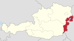
Burgenland (German pronunciation: [ˈbʊʁɡn̩lant]; Hungarian: Őrvidék; Croatian: Gradišće; Slovene: Gradiščanska; Czech: Hradsko; is the easternmost and least populous state of Austria. It consists of two statutory cities and seven rural districts, with in total 171 municipalities. It is 166 km (103 mi) long from north to south but much narrower from west to east (5 km (3.1 mi) wide at Sieggraben). The region is part of the Centrope Project.
Burgenland is the seventh largest of Austria's nine states, or Bundesländer, at 3,962 km2 (1,530 sq mi). The highest point in the province is on the Geschriebenstein, whose summit is 884 metres (2,900 ft) above sea level, but the highest point in Burgenland itself is 879 metres above sea level; the lowest point (which is also the lowest point of Austria) at 114 metres (374 ft), is in the municipal area of Apetlon.
Burgenland borders the Austrian state of Styria to the southwest, and the state of Lower Austria to the northwest. To the east it borders Hungary. In the extreme north and south there are short borders with Slovakia and Slovenia respectively.
Burgenland and Hungary share the Neusiedler See, a lake known for its reeds and shallowness, as well as its mild climate throughout the year. The Neusiedler See is Austria's largest lake, and is a great tourist attraction, bringing ornithologists, sailors, and wind and kite surfers into the region north of the lake.
...
Wikipedia


