Superior Hiking Trail
| Superior Hiking Trail | |
|---|---|

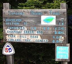
A sign at a Superior Hiking Trail trailhead near Finland, Minnesota
|
|
| Length | 310 mi (499 km) |
| Location | Cook / Lake / Saint Louis / Carlton counties, Minnesota, United States |
| Trailheads | Near Jay Cooke State Park; Canada–US border near Lake Superior |
| Use | Hiking |
| Elevation | |
| Highest point | 1,829 ft (557 m) |
| Lowest point | Lake Superior, 602 ft (183 m) |
| Hiking details | |
| Trail difficulty | Moderate |
| Season | Late spring to early fall |
| Sights | Lake Superior, Iron Range, state parks |
| Hazards | Severe weather, black bears, Lyme disease |
The Superior Hiking Trail, also known as the SHT, is a 310-mile (499 km) long footpath in northeastern Minnesota that follows the ridgeline overlooking Lake Superior for most of its length. The path is 18 inches (46 cm) wide and is set in the middle of a 4-foot (1.2 m) clearing. The footpath travels through forests of birch, aspen, pine, fir, and cedar. Hikers enjoy views of boreal forests, the Sawtooth Mountains, babbling brooks, rushing waterfalls, and abundant wildlife. The lowest point in the path is 602 feet (183 m) above sea level and the highest point is 1,829 feet (558 m) above sea level. The footpath is intended for hiking only. Motorized vehicles, mountain bikes, and horses are not allowed on the trail. Many people use the footpath for long-distance hiking. Facilitating this purpose are 93 backcountry, fee-free campsites.
Construction of the Superior Hiking Trail began in the mid-1980s, and the trail now extends 313 miles (504 km) from Duluth to the Canada–US border, 17 miles (27 km) of which are spur trails to the main trail. Inspiration for building the trail came from the Appalachian Trail, which extends from Georgia to Maine. The Superior Hiking Trail Association (SHTA) was formed in 1986 to manage the construction, planning, and day-to-day care of the trail. The SHTA received several grants from the State of Minnesota, three of which were from the Legislative Commission on Minnesota Resources. This money helped jump start the construction of the trail and funded construction for the first few years. In 1987, the trail had an opening ceremony at Britton Peak to celebrate the beginning of construction. The ceremony included a log-cutting event and many state government officials and SHTA founders attended. Three years later, in August 1990, the trail had reached a half-way mark and another celebration was held. That celebration included a 140-mile (225 km) hike for about a dozen brave hikers who completed it in 12 days. Since 1991, a 100-mile (161 km) ultramarathon known as the "Superior 100", along with several other races, has been hosted annually on the Superior Hiking Trail. In 1995, Paul Hlina, who was paralyzed from the waist down, hiked the entire trail on crutches and is now known as the first hiker to thru-hike the trail. He raised $16,000 in pledges for the Superior Hiking Trail Association, the non-profit organization which maintains the trail. Trail construction and improvements continued, and in 2013 the Superior Hiking Trail became a continuous footpath from Jay Cooke State Park to the 270 Degree Overlook near the Canada–US border.
...
Wikipedia
