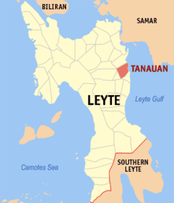
Tanauan, Leyte
| Tanauan | ||
|---|---|---|
| Municipality | ||
|
||
 Map of Leyte with Tanauan highlighted |
||
| Location within the Philippines | ||
| Coordinates: 11°07′N 125°01′E / 11.12°N 125.02°ECoordinates: 11°07′N 125°01′E / 11.12°N 125.02°E | ||
| Country | Philippines | |
| Region | Eastern Visayas (Region VIII) | |
| Province | Leyte | |
| District | 1st district of Leyte | |
| Barangays | 54 | |
| Government | ||
| • Mayor | Pelagio Tecson, Jr. (LP) | |
| Area | ||
| • Total | 78.41 km2 (30.27 sq mi) | |
| Population (2015 census) | ||
| • Total | 55,021 | |
| • Density | 700/km2 (1,800/sq mi) | |
| Time zone | PST (UTC+8) | |
| ZIP code | 6502 | |
| Dialing code | +63 (0)53 | |
| Income class | 2nd municipal income class | |
| 083748000 | ||
| Electorate | 32,935 voters as of 2016 | |
| Website | www |
|
Tanauan is a 2nd class municipality in the province of Leyte, Philippines. According to the 2015 census, it has a population of 55,021 people.
Tanauan is one of the oldest towns in Leyte dating back to the year 1710. It comprise of fifty-four (54) barangays. The town has been baptized the title of “Cradle of the Intellectuals” or "Bungto Han Kamag-araman" since the Spanish colonial period. Tanauan is approximately eighteen (18) kilometers south of Tacloban City which is the Capital of the Eastern Visayas Region. It is bounded on the north by the Municipality of Palo, on the south by the Municipality of Tolosa, on the west by the Municipalities of Dagami and Tabon-Tabon, and on the east by San Pedro Bay.The town was heavily damaged by Super Typhoon Haiyan (Yolanda) in November 2013.
Tanauan is politically subdivided into 54 barangays.
The town got its name from a towering Molave tree which served as a look-out tower. “Tan-awan” or "Taran-awan" means to look-out in the Waray-Waray language. A person who serves as a look-out would watch for the feared Moro Pirates who would every now and then plunder and loot the settlements along the coast.
The first known settlers of Tanauan were the family of Calanao with his wife and daughter. In 1661, Juanillo Siengco’s family joined the Calanao family in the settlement along the bank of Bukid River at the foot of Adil Hill. By the time their settlements were more developed, the plundering of the Moros along the coast became intensified, and for their refuge, they built a stone-walled enclosure called "cuta” in the area of Buaya. In the course of time, Juanillo’s son Josef, married Calanao’s daughter, Sangod, and from the families of Juanillo Siengco and Calanao a tribe was formed which gave Tanauan its first tribal leaders.
In 1710, the first town officials were appointed by the Spanish authorities during the Spanish reign in the Philippines. From 1710 up to the end of the Spanish Colonial period in 1900 and the start of American occupation, forty-seven (47) persons became chief executives of the municipality.
Tolosa, an adjacent town to the south of Tanauan, was once part of the municipality. Through the efforts of certain Magdalino Vivero and Domingo Camacho, they petitioned the Spanish government to grant Tolosa autonomy from the municipality. The petition was granted in 1852.
...
Wikipedia


