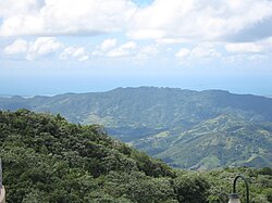
Toro Negro State Forest
| Toro Negro State Forest Spanish: Bosque Estatal de Toro Negro |
|
|---|---|

Bosque Estatal de Toro Negro shown in the foreground
|
|
| Geography | |
| The map shows the location of ranger's office at Bosque Estatal de Toro Negro | |
| Location | PR-143, km. 32.4 and PR-149 km 39.0, Ponce/Jayuya/Orocovis/Ciales/Juana Diaz, Puerto Rico |
| Coordinates | 18°10′24″N 66°29′32″W / 18.17342°N 66.49231°WCoordinates: 18°10′24″N 66°29′32″W / 18.17342°N 66.49231°W |
| Elevation | 4,390 feet (1,340 m) |
| Area | 8,204 cuerdas (7,968 acres) (32.24 km2) |
| Status | Public, Commonwealth |
| Established | 1934 with 6,800 acres |
| Visitation | 126,916(2008) |
| Events | Cerro Maravilla murders |
| Governing body | Puerto Rico DRNA |
| Website | www |
| Ecology | |
| Ecosystem(s) |
Subtropical Moist Zone (31% of the forest): -Tabonuco forest. Lower Mountain Wet Zone (69% of the forest): -Micropholis Buchenavia forest, -Mountain palm forest, -Cloud forest. |
| WWF Classification | Puerto Rican moist forests |
| Disturbance | -Hurricanes and Landslides |
| Forest cover | 81% - 99% |
| Dominant tree species |
Melastomaceae (16 species), Lauraceae (11 species), Myrtaceae (10 species) |
| Indicator plants |
Tabonuco (Dacryodes excelsa), Ausubo (Manilkara bidentata), Montillo (Sloanea berteroana) |
| Protected Areas at Bosque Estatal de Toro Negro | |
|---|---|
|
IUCN category IV (habitat/species management area)
|
|
| Location |
Puerto Rico Ponce (Approx 40%), Jayuya (Approx 30%), Orocovis (Approx 15%), Ciales (Approx 10%), and Juana Diaz (Approx 5%) |
| Nearest city | Ponce |
| Area | 7,967.6 acres (3,224.4 ha) |
| Established | 1934 |
| Visitors | 126,916 (in 2008) |
| Governing body | Puerto Rico DRNA |
| Highest peaks at Toro Negro | |||||||||||||||||||||||||||||||||||||||||||||||||||||||||||||||||||||||||||||||||||||||||||||||||||||||||||||||||||||||||||||
|---|---|---|---|---|---|---|---|---|---|---|---|---|---|---|---|---|---|---|---|---|---|---|---|---|---|---|---|---|---|---|---|---|---|---|---|---|---|---|---|---|---|---|---|---|---|---|---|---|---|---|---|---|---|---|---|---|---|---|---|---|---|---|---|---|---|---|---|---|---|---|---|---|---|---|---|---|---|---|---|---|---|---|---|---|---|---|---|---|---|---|---|---|---|---|---|---|---|---|---|---|---|---|---|---|---|---|---|---|---|---|---|---|---|---|---|---|---|---|---|---|---|---|---|---|---|
|
|||||||||||||||||||||||||||||||||||||||||||||||||||||||||||||||||||||||||||||||||||||||||||||||||||||||||||||||||||||||||||||
| Cerro de Punta | |
|---|---|
| Highest point | |
| Elevation | 1,338 m (4,390 ft) |
| Prominence | Tallest peak in Puerto Rico |
| Geography | |
| Location | Ponce & Jayuya |
| Parent range | Cordillera Central |
| Topo map | USGS |
| Geology | |
| Age of rock | 2.3 billion years old |
| Mountain type | Igneous rock |
| Climbing | |
| Easiest route | PR-143, km 17.0 |
| 2nd highest at Toro Negro | |
| Highest point | |
| Elevation | 1,296 m (4,252 ft) |
| Prominence | 2nd highest peak in Puerto Rico |
| Geography | |
| Location | Ponce & Jayuya |
| Parent range | Cordillera Central |
| Climbing | |
| Easiest route | PR-143, km 18.2 |
| 3rd highest at Toro Negro | |
| Highest point | |
| Elevation | 1,263 m (4,144 ft) |
| Prominence | 3rd highest peak in Puerto Rico |
| Geography | |
| Location | Ciales & Jayuya |
| Parent range | Cordillera Central |
| Climbing | |
| Easiest route | End of PR-539 South, then Hike |
| 4th highest at Toro Negro | |
| Highest point | |
| Elevation | 1,205 m (3,953 ft) |
| Prominence | 5th highest peak in Puerto Rico Site of Cerro Maravilla murders |
| Geography | |
| Location | Ponce, Puerto Rico |
| Parent range | Cordillera Central |
| Climbing | |
| Easiest route | PR-577, km 0.5 |
| 5th highest at Toro Negro | |
| Highest point | |
| Elevation | 1,075 m (3,527 ft) |
| Prominence | 10th highest peak in Puerto Rico |
| Geography | |
| Location | Villalba, Puerto Rico |
| Parent range | Cordillera Central |
| Climbing | |
| Easiest route | PR-143, km 32.4 |
| Highest point | |
| Elevation | 1,058 m (3,471 ft) |
| Prominence | 12th highest peak in Puerto Rico |
| Geography | |
| Location | Orocovis, Puerto Rico |
| Parent range | Cordillera Central |
| Climbing | |
| Easiest route | PR-143, km 32.4 |
...
Wikipedia

