Typhoon Freda
| 1962 Pacific typhoon season | |
|---|---|
Season summary map
|
|
| Seasonal boundaries | |
| First system formed | February 3, 1962 |
| Last system dissipated | December 10, 1962 |
| Strongest storm | |
| Name | Emma |
| • Maximum winds | 260 km/h (160 mph) (1-minute sustained) |
| • Lowest pressure | 890 hPa (mbar) |
| Seasonal statistics | |
| Total depressions | 38 |
| Total storms | 30 |
| Typhoons | 23 |
| Super typhoons | 6 |
| Total fatalities | at least 1,700 |
| Total damage | $325 million (1962 USD) |
| Related articles | |
| Tropical Storm (JMA) | |
| Tropical Storm (SSHWS) | |
| Duration | February 3 – February 5 |
|---|---|
| Peak intensity | 85 km/h (50 mph) (1-min) 1002 hPa (mbar) |
| Typhoon (JMA) | |
| Category 4 typhoon (SSHWS) | |
| Duration | April 15 – April 24 |
|---|---|
| Peak intensity | 240 km/h (150 mph) (1-min) 930 hPa (mbar) |
| Tropical Storm (JMA) | |
| Category 1 typhoon (SSHWS) | |
| Duration | May 14 – May 22 |
|---|---|
| Peak intensity | 150 km/h (90 mph) (1-min) 980 hPa (mbar) |
| Tropical depression (JMA) | |
| Tropical depression (SSHWS) | |
| Duration | May 21 – May 25 |
|---|---|
| Peak intensity | 55 km/h (35 mph) (1-min) 1002 hPa (mbar) |
| Typhoon (JMA) | |
| Tropical Storm (SSHWS) | |
| Duration | May 25 – May 31 |
|---|---|
| Peak intensity | 110 km/h (70 mph) (1-min) 990 hPa (mbar) |
| Typhoon (JMA) | |
| Category 1 typhoon (SSHWS) | |
| Duration | July 6 – July 10 |
|---|---|
| Peak intensity | 150 km/h (90 mph) (1-min) 985 hPa (mbar) |
| Tropical depression (JMA) | |
| Tropical depression (SSHWS) | |
| Duration | July 8 – July 13 |
|---|---|
| Peak intensity | 55 km/h (35 mph) (1-min) 1004 hPa (mbar) |
| Tropical depression (JMA) | |
| Tropical depression (SSHWS) | |
| Duration | July 10 – July 13 |
|---|---|
| Peak intensity | 55 km/h (35 mph) (1-min) 994 hPa (mbar) |
| Typhoon (JMA) | |
| Category 1 typhoon (SSHWS) | |
| Duration | July 17 – July 25 |
|---|---|
| Peak intensity | 150 km/h (90 mph) (1-min) 970 hPa (mbar) |
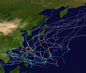
The 1962 Pacific typhoon season had no official bounds; there was activity in every month but January, March, and June, but most tropical cyclones form in the northwestern Pacific Ocean between May and November and this conventionally delimits the season.
The majority of the Pacific typhoons in 1962 formed in the Pacific Ocean north of the equator and west of the International Date Line with two exceptions: Tropical Depressions Fifty and Sixty-three formed in the Central Pacific. Storms that form east of the date line and north of the equator are called hurricanes; see 1962 Pacific hurricane season. All tropical depressions are assigned a number. Most systems reaching tropical storm strength were assigned a name; all typhoons were named.
Ninety tropical waves formed in the 1962 season. Only 78 of these became major easterly waves. 38 of these waves became tropical depressions, 30 became storms and 23 become typhoons. This record of 24 typhoons beat 1952 record which had 21. This record was beaten in the 1964 season with 26 typhoons. Six super typhoons formed in 1962 which were Georgia, Emma, Ruth, Opal, Amy and Karen. Even with the high activity, only about half the cyclones in 1962 made landfall. There were also seventeen suspect cyclones discovered by the JTWC in post-season reports. Three were reported to reach typhoon intensity, three at tropical storm status and two needed tropical depression warnings.
Two depressions, 50 and 63, formed in the Central Pacific under the Joint Hurricane Warning Center's (now The Central Pacific Hurricane Center) jurisdiction and were included in the JTWC archives. Both depressions stayed out to sea and had no effects on land. The Central Pacific also got Nora, Opal, Ruth, Gilda, Emma and Thelma, the remnants of Nadine and the ending of Karen near the end of the season. Six typhoons entered the Bering Sea: Nora, Opal, Ruth, Thelma, Amy and Emma. Four of the six were super typhoons. Three typhoons just missed entering the Bering Sea: Typhoons Hope, Sarah and Gilda. Also, Typhoons Georgia, Hope, Joan, Nora, Opal, Ruth, Thelma, Wanda, Amy, Emma, Gilda, Jean and Karen all lasted for at least one week with Opal lasting for eighteen straight days from a wave to the day the JMA ceased advisories.
The second tropical wave of the season formed on the morning of February 2 off the southeastern coast of the Philippines. The storm quickly intensified into a tropical depression and soon into the first tropical storm of the 1962 season. The intensifying tropical cyclone went through the latter half of February 2 as a 45 mph (70 km/h) tropical storm, progressing southwest towards Indonesia. However, on the early morning of February 3, the storm curved to the northeast and away from Indonesia. The strength remained unchanged during the day and before long reached its peak winds speeds of 50 mph (85 km/h). Continuing northward away from the coast of the Philippines, Fran remained at peak winds until the evening of February 4. During the morning hours of February 5, Fran dropped down to 45 mph (70 km/h) tropical storm and continued northward, weakening to 40 mph (60 km/h). On the morning of February 6, Fran weakened into a tropical depression and the final advisory was released six hours after.
...
Wikipedia


